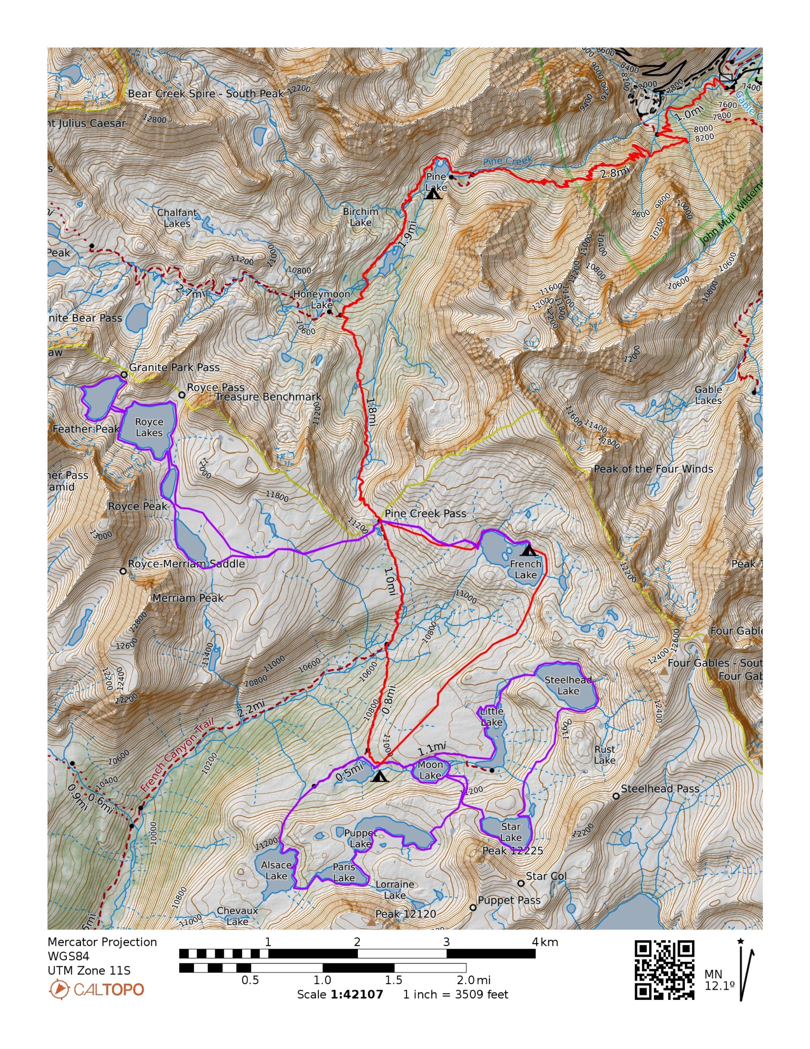
Pine Creek > French Canyon
John Muir Wilderness · Inyo National Forest · White Mountain Ranger District
Out-and-back · 20.2 miles · +4,808 / −4,783 ft
Day hikes · Steelhead+Star 5.7 mi · Alsace+Paris 4.56 mi · Royce Lakes 9.58 mi
Day hikes · Steelhead+Star 5.7 mi · Alsace+Paris 4.56 mi · Royce Lakes 9.58 mi
The Country
- Wilderness
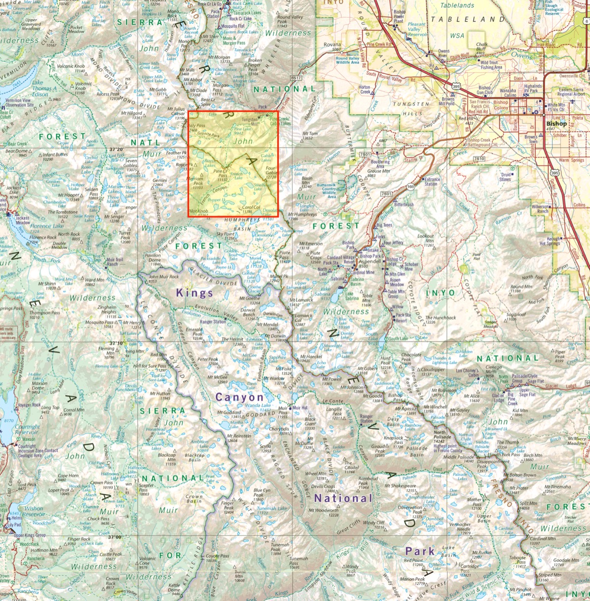
- John Muir Wilderness, Inyo National Forest. All lakes in the French Canyon cluster fall in Fresno County despite Pine Creek access being in Inyo County — the Erdman CDFW eastern Sierra fishing guide does not cover them.
- Area
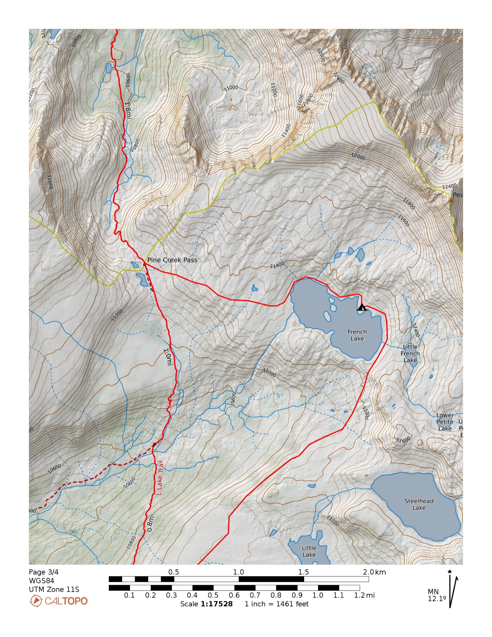
- Pine Creek Canyon and French Canyon, a high granite basin southeast of Pine Creek Pass. Base camp at French Lake (11,240 ft). Day fishing options radiate into the Steelhead–Star basin, the Alsace–Paris basin, and Royce Lakes.
- Season
- Mid-July through September. Pine Creek Pass (11,100 ft) can hold snow into late June. Snow-dependent; confirm conditions with the ranger station for any trip before mid-July.
- Access
- Pine Creek TH via Round Valley Rd off US-395, ~20 miles north of Bishop. Paved access to a large parking area at 7,400 ft. No high-clearance required.
- Elevation
- 7,396–11,290 ft (base route) · 11,783 ft (Royce Lakes day hike high point). All camps above 11,000 ft. Treeline ends near Honeymoon Lake at ~10,500 ft.
- Trailhead
- Out-and-back · Pine Creek TH (JM11) · Round Valley Rd · quota trailhead
- Live map
- Open CalTopo — map pending
The RouteDistanceGainLoss
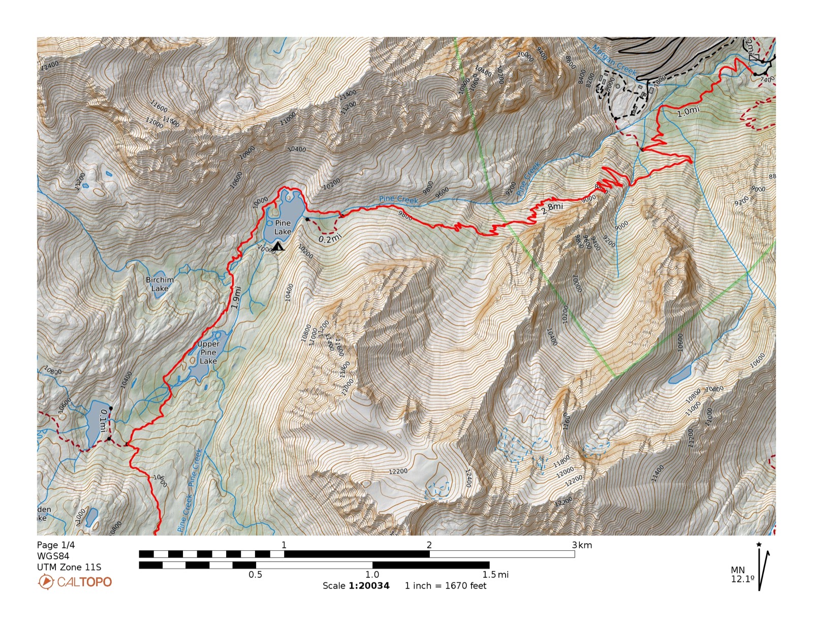
Pine Creek TH → Pine Lake
4.21 mi
+2,618
−56 ft
Trailhead (7,396 ft) → Pine Lake (9,964 ft) · steady trail climb up Pine Creek Canyon
+2,618−56 ft
Pine Lake → Elba Lake
5.23 mi
+1,562
−570 ft
Pine Lake (9,957 ft) → Elba Lake (10,900 ft) · climb to high basin with short descent mid-route
+1,562−570 ft
Elba Lake → French Lake XC
2.1 mi
+411
−65 ft
Elba Lake (10,924 ft) → French Lake (11,290 ft) · cross-country Class 1 · no maintained trail · mark waypoint on GPS
+411−65 ft
French Lake → Pine Creek TH Partial XC
8.64 mi
+217
−4,092 ft
French Lake (11,348 ft) → Pine Creek Pass (XC, ~0.75 mi) → Pine Creek TH (7,396 ft) · long descent on maintained trail
+217−4,092 ft
Total Route
20.2 mi
+4,808
−4,783 ft
Day hikes — fishing from base camp
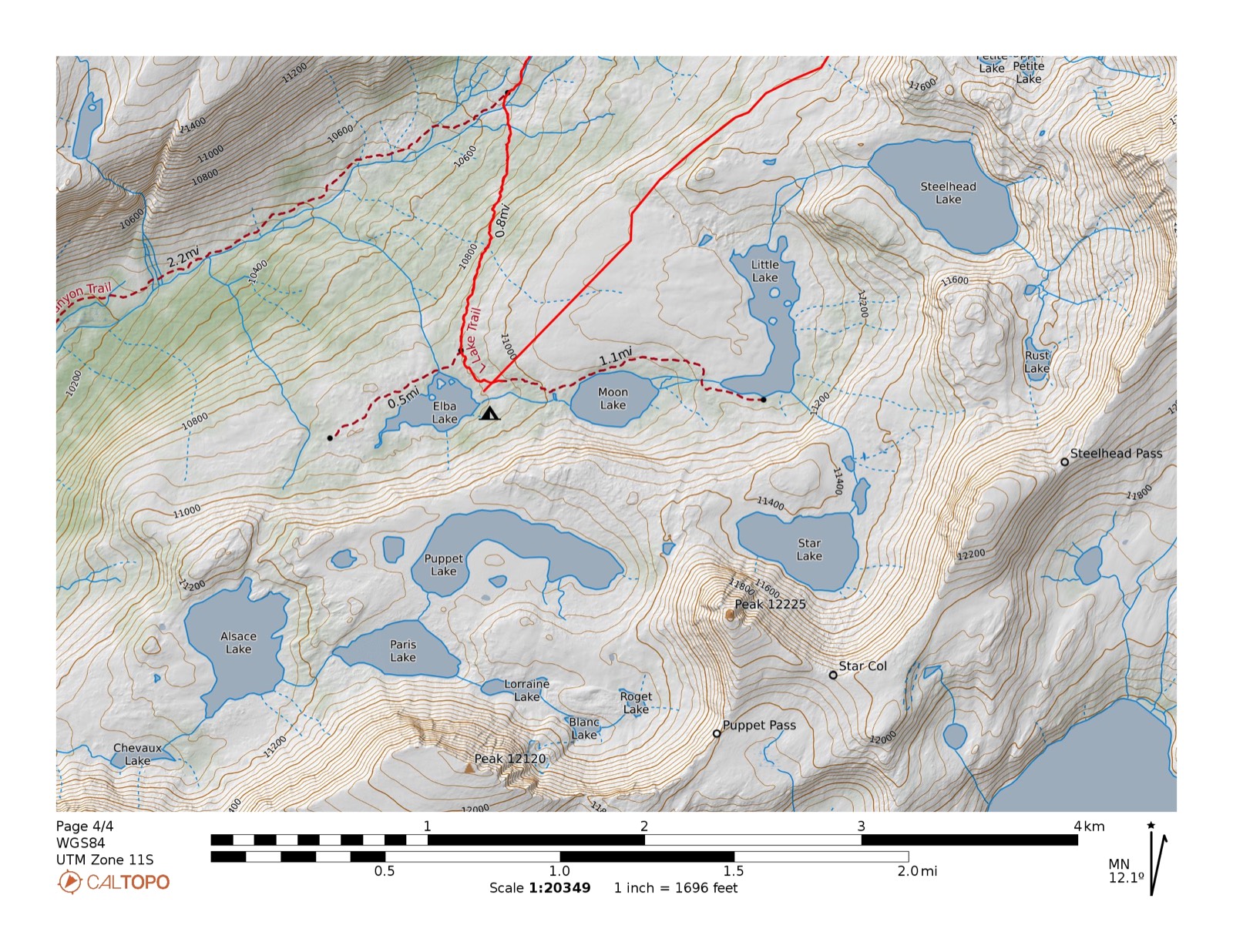
Elba → Steelhead + Star Partial XC
5.7 mi
+654
−653 ft
Elba Lake (10,910 ft) → L Lake → Steelhead Lake → Star Lake · end of maintained trail at L Lake, XC above · 10,910–11,431 ft
+654−653 ft
Elba → Alsace + Paris Partial XC
4.56 mi
+591
−592 ft
Elba Lake (10,909 ft) → Alsace Lake → Paris Lake · 10,909–11,388 ft
+591−592 ft
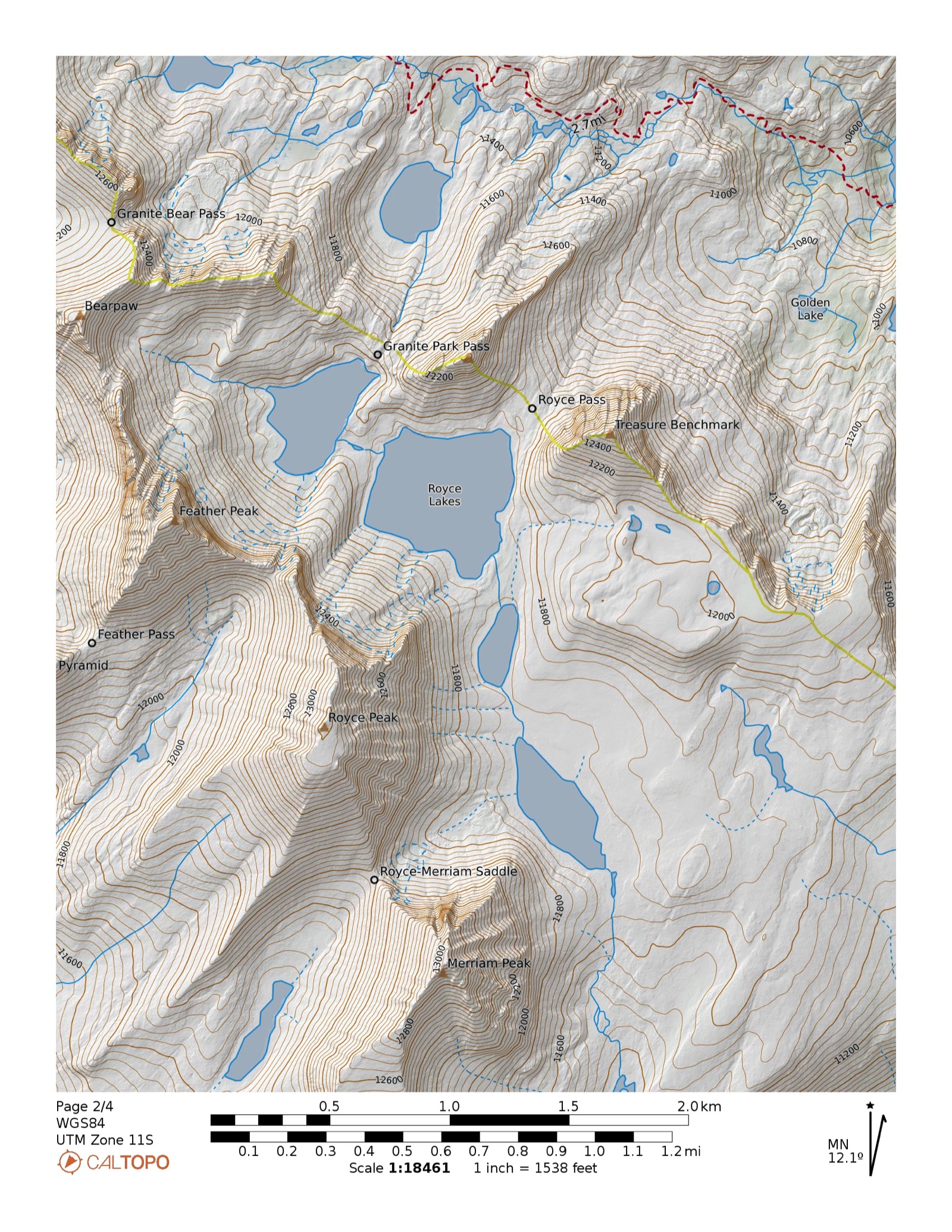
French Lake → Royce Lakes XC
9.58 mi
+1,371
−1,374 ft
French Lake (11,260 ft) → Royce Lakes basin (11,400–11,775 ft) · out-and-back · exposed high terrain · 11,117–11,783 ft
+1,371−1,374 ft
The Fishing
| Lake | Rating | Species | Size | Notes |
|---|---|---|---|---|
| Puppet Lake (11,220 ft) | ●●●Excellent | Golden trout | to 5 lbs | ⚠️ Stocking may be discontinued for MYLF — verify before trip. 1963 survey: goldens to 5 lbs. "Reputation of having some of the largest Goldens within the Sierra." 51 acres. |
| Star Lake (11,400 ft) | ●●●Excellent | Golden trout | to 18 in | "Known for Goldens up to 18 in." — CDFW Region 4 article. Biennially stocked aerial. Primary target in the Steelhead basin. 40 acres. |
| French Lake (11,240 ft) | ●●●Excellent | Golden trout | to 15 in | Base camp lake. Biennially stocked aerial. 59 acres, up to 58 ft deep. Fish the east shore sheltered from afternoon wind. Primary layover target. |
| Royce Lakes (11,400–11,775 ft) | ●●●Good | Golden trout | to 18+ in | Lakes 2, 4, 5 stocked biennially until 2006; self-sustaining source. 1963 survey: "many over 18 in." at Lake 4. Extreme wind and exposed granite — plan for short calm windows. |
| Paris Lake (11,160 ft) | ●●●Good | Golden trout | to 17 in | Self-sustaining (last stocked 2000). 1963 survey: goldens to 17 in. 25 acres. |
| Steelhead Lake (11,330 ft) | ●●●Good | Golden trout | No data | Biennially stocked aerial. 55 acres, >90 ft deep — fish grow large between stocking cycles. Confirmed excellent (Calipidder 2010). Severe wind; best site southwest shore. |
| L Lake (11,050 ft) | ●●●Good | Golden trout | 8–12 in | Self-sustaining. Named for its L-shape, 37 acres. "Fish biting well" per trip report. End of maintained trail — gateway to Star, Puppet, and Steelhead above. |
| Elba Lake (10,900 ft) | ●●●Good | Golden trout | 8–12 in | Strongly self-sustaining (2006 DFG survey). Day-hike hub — trail ends here. Sheltered campsites on east shore. Reliable. |
| Moon Lake (10,998 ft) | ●●●Good | Golden trout | 8–12 in | Self-sustaining. Notably wind-sheltered when afternoon gusts hit the other lakes. Winter kill risk. 18 acres. |
| Alsace Lake (11,060 ft) | ●●●Fair | Golden trout | avg 8 in | Self-sustaining (last stocked 1994). Large lake at 53 acres, up to 60 ft deep. Most fish small but worth mid-day streamers in deeper water. |
Techniques: Dry flies (Parachute Adams, Elk Hair Caddis, Yellow Humpy, Hopper #14–18) · Nymphs (Hare's Ear, Prince #16–18) along rocky shallows · Streamers (Woolly Bugger, Mohair Leech #8–10) mid-day in deeper lakes. Fish mornings — afternoon wind and lightning are common above 11,000 ft.
Note: All French Canyon lakes fall in Fresno County — not covered by the CDFW Erdman eastern Sierra guide. CA fishing license required. 5 trout/day, 10 in possession. Call CDFW Bishop (760-872-1171) to verify current stocking cycles before the trip — stocking is biennial and timing isn't published in advance.
Sources: Fly Fishing the Sierra — French Canyon · CDFW Region 4 stocking records · Calipidder trip report (2010) · High Sierra Topix threads t=24671, t=23896
Maps
Logistics
- Permit
- Required · JM11 Pine Creek Pass · Quota: 15 people/day · recreation.gov #233262 · Opens 6 months before entry date at 7:00 AM PT · $6/permit + $5/person · Walk-up: 40% held until 2 weeks out
- Campfires
- No campfires above 10,000 ft · Order 05-04-50-25-04, effective through June 2027 · This is a standing order, not a seasonal restriction · Canister stove only
- Bears
- Hard-sided canister required in practice · Treeline ends at Honeymoon Lake (~10,500 ft) · All camps on this route are above that · Ranger station rents canisters
- Camping
- 100 ft from all water, trails, and other parties · Durable surfaces only (granite benches preferred) · No designated sites
- Group size
- Maximum 15 persons
Permit tip: The Bishop corridor fills fast at the 6-month window. Pine Creek quota is only 15/day — don't wait. Italy Pass (JM10) is an alternate entry (8/day quota) but requires a different approach.
For More Information
White Mountain Ranger Station (Bishop)
(760) 873-2483
CDFW Bishop Field Office
(760) 872-1171
Inyo County Sheriff — Search & Rescue
(760) 878-0383
Wind at French Lake: Reports consistently note strong channeled wind up Pine Creek Canyon, especially as temperatures drop. Seek sites sheltered by granite outcrops on the east or northeast side of the lake basin.
French Canyon ≠ Erdman guide: Lakes fall in Fresno County despite Inyo County trailhead access. Use flyfishingthesierra.com/french-canyon as primary fishing reference.
French Canyon ≠ Erdman guide: Lakes fall in Fresno County despite Inyo County trailhead access. Use flyfishingthesierra.com/french-canyon as primary fishing reference.
Pine Creek › French Canyon · John Muir Wilderness · Inyo NF
Profiles: CalTopo · Distances & gain/loss from CalTopo profiles · Verify conditions before departure