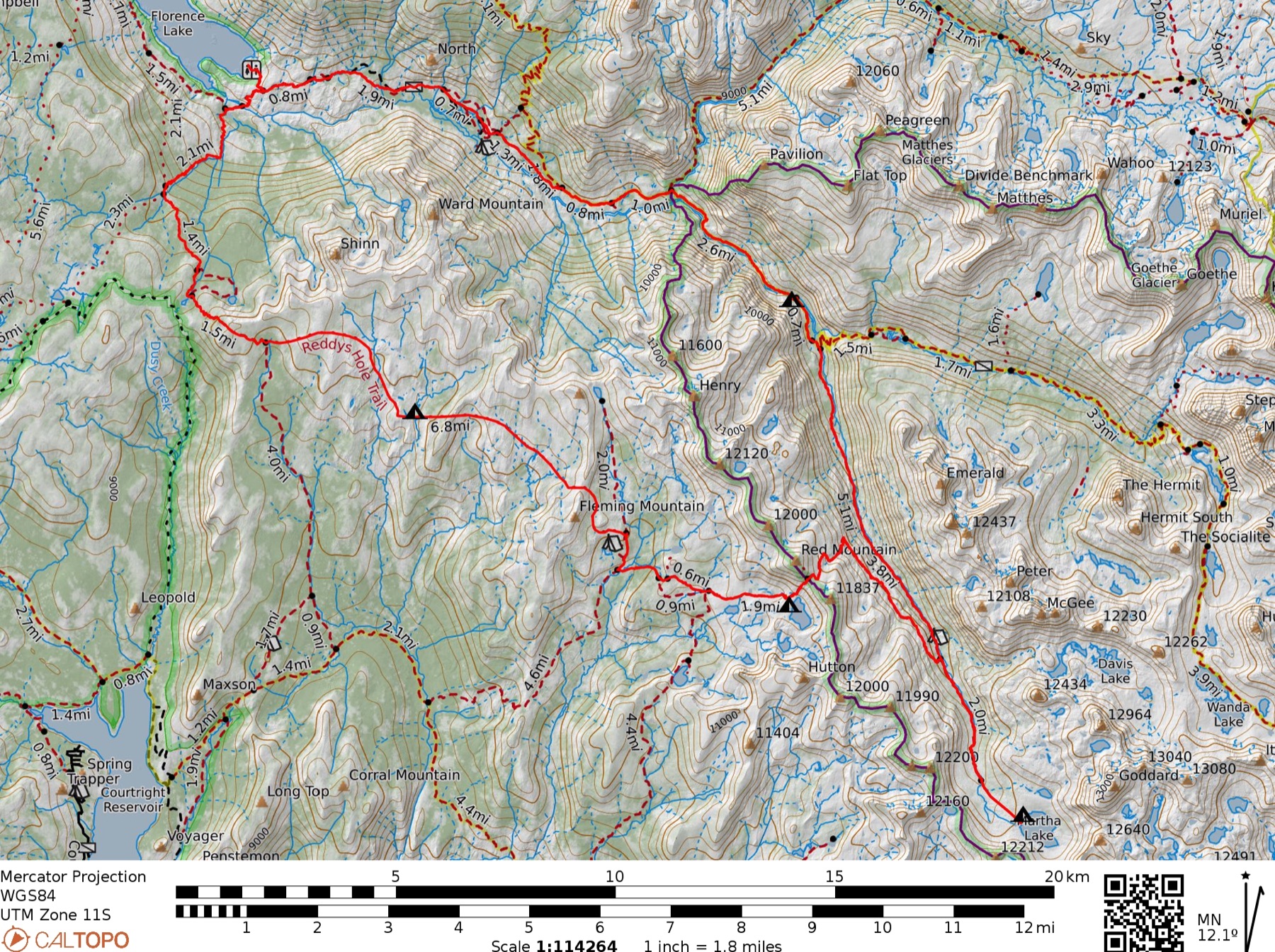
Florence Lake > Martha Lake Loop
- Wilderness
- John Muir Wilderness, Sierra National Forest. Route crosses into Kings Canyon National Park near the Le Conte Divide at Martha Lake — verify permit requirements for both zones before departure.
- Area
- Goddard Canyon and Red Mountain Basin, flanking the Le Conte Divide. Goddard Canyon is among the least-visited drainages in the Sierra reachable without a full expedition — expect near-total solitude above the JMT junction.
- Season
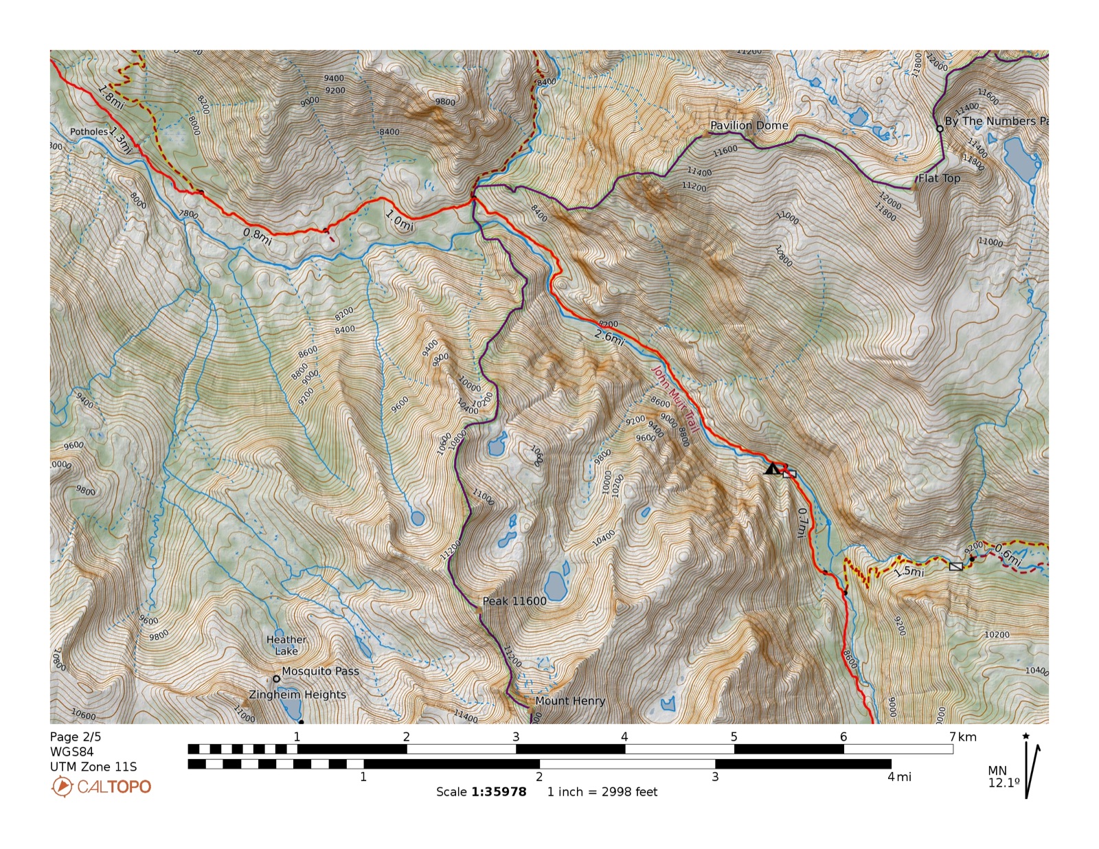
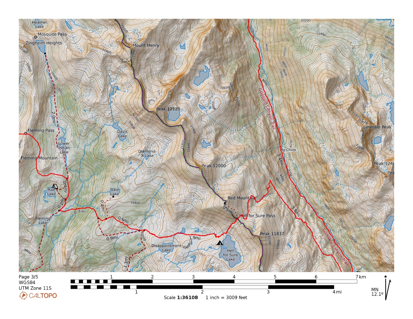
- Mid-July through September. Martha Lake basin can hold significant ice through August. Hell for Sure Pass (11,286 ft) may be snowbound into early July. Afternoon thunderstorms common July–August.
- Access
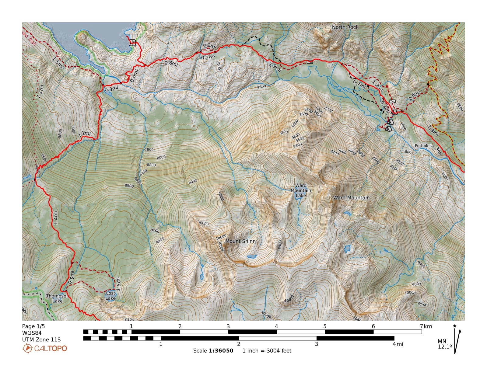
- Florence Lake TH via Kaiser Pass Rd (CA-168 → FR 80), ~65 mi east of Fresno (~3 hrs). Road is one-lane paved-then-dirt with turnouts — 15 mph, yield uphill. High clearance recommended. Ferry across Florence Lake saves 4.25 miles (last run ~5pm; confirm current schedule).
- Elevation
- 7,320–11,286 ft. High point at Hell for Sure Pass on the Le Conte Divide. Route descends deep into Goddard Canyon (treeline ~10,000 ft) before climbing back out over the divide.
- Trailhead
- Loop · Florence Lake TH (J57) · Kaiser Pass Rd
- Live map
- Open CalTopo
| Lake / Water | Rating | Species | Size | Notes |
|---|---|---|---|---|
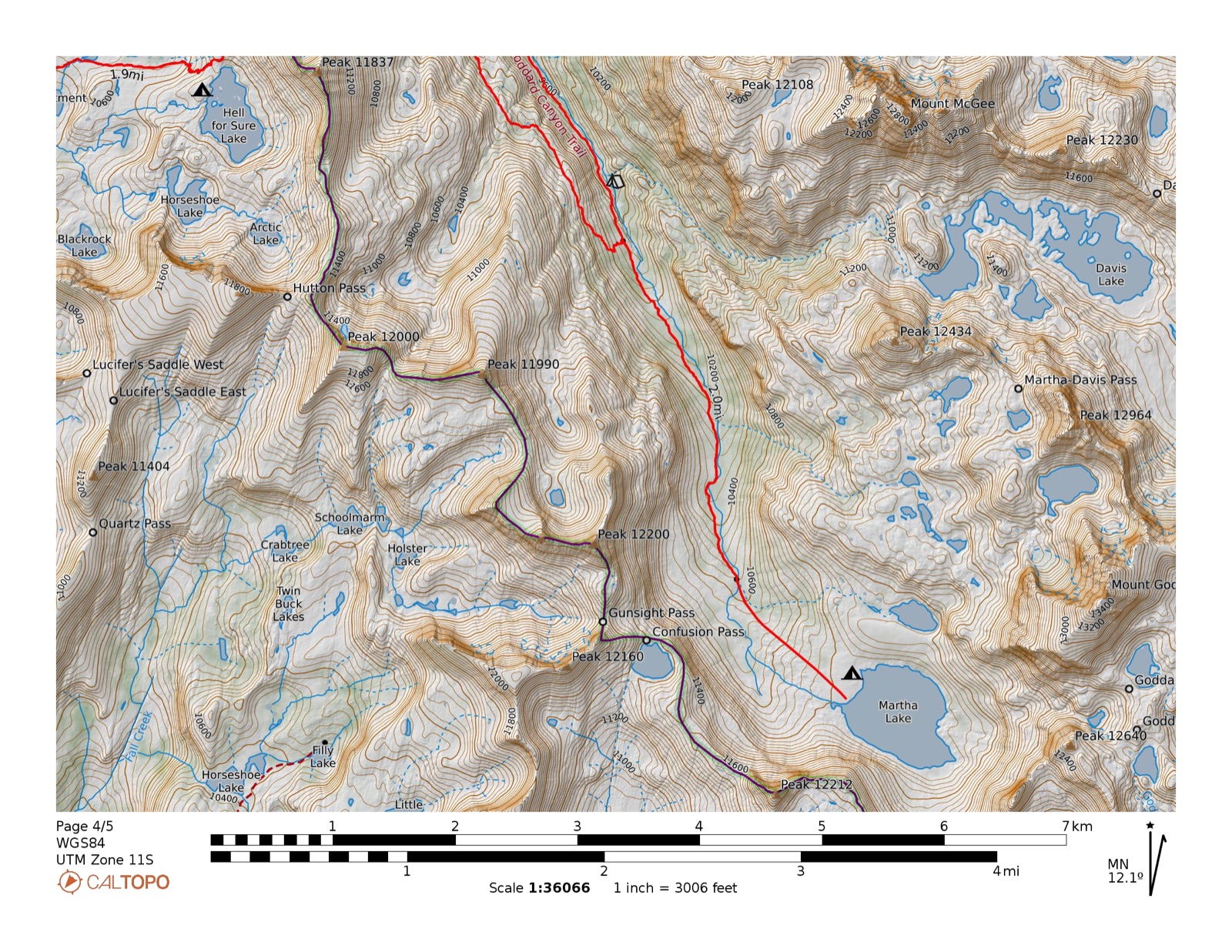
| Hell for Sure Lake | ●●●Excellent | Brook trout | 8–10 in | Self-sustaining wild fishery. Multiple reports of fish on every cast — "fat brookies." No CDFW stocking on record. 59 acres with 11 rocky islands. |
| Martha Lake (11,010 ft) | ●●●Excellent | Golden trout | 12–16+ in | Self-sustaining wild goldens — confirmed twice. SVEF 1981: multiple fish including a 2½-lb golden; flesh deep red from freshwater shrimp in the lake. Scott & Jake 2010: good-to-excellent, 12–14"+ Plan around mid-July — lake can hold ice into August. |
| Upper Goddard Canyon (pools below Martha Lake) | ●●●Good | Golden trout | — | Wild California golden trout in deep river pools confirmed by trip reports. Fish the canyon on the approach — the upper river is a gem that sees almost no pressure. |
| Devils Punchbowl (10,098 ft) | ●●●Good | Brook trout | to 12 in | Best fishing in Red Mountain Basin. Brookies visible in the shallows and actively feeding; multiple reports of "nearly a foot long" fish with deep red coloring. Fish the outlet pools toward Rae Lake too. Popular camp — has the most foot traffic in the basin. |
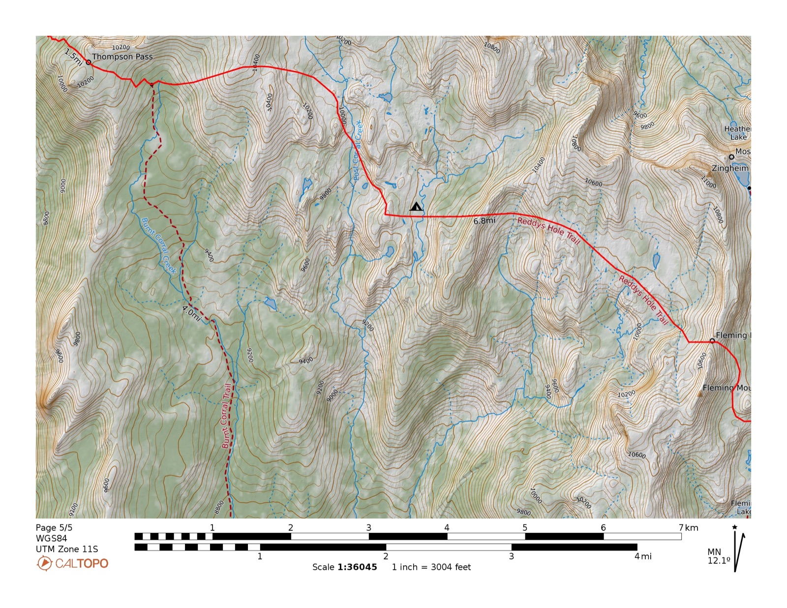
| Fleming Lake (~9,750 ft) | ●●●Good | Brook trout | 8–10 in | Beautiful lake with LeConte Divide views; self-sustaining wild brookies. No campfire within ¼ mi. |
| Disappointment Lake (10,342 ft) | ●●●Good | Brook trout | 8–10 in | Trail-accessible; flat established camp on east shore; often uncrowded despite the quality. Active brookies confirmed (flyfishingthesierra.com). No campfire within ¼ mi. |
| Blackrock Lake (10,444 ft) | ●●●Good | Brook trout | 8–10 in | Best established camps in the upper basin — good flat sites against the cliff wall. Optimal layover base: reach Horseshoe and Arctic lakes above, Devils Punchbowl below. |
| Rae Lake (~9,889 ft) | ●●●Good | Brook trout | 8–10 in | On the Hell for Sure Trail; brook trout 8–10 in. Good granite slab camping nearby. No campfire within ¼ mi. |
| Big Shot Lake | ●●●Good | Brook trout | to 12 in | First-hand: Scott 2008, brook trout to 12 in. Scenic lake above Devils Punchbowl. |
| Horseshoe Lake (10,737 ft) | ●●●Fair | Brook trout (likely) | — | Unmapped cliffs block most of the shoreline — multiple trip reports specifically warn about this. Approach from Blackrock Lake to the south only. Scenic "favorite" despite the access challenge; very limited camping. |
| Arctic Lake (10,843 ft) | ●●●Fair | Unknown | — | Highest lake in the basin. Fishing status uncertain — likely marginal at this elevation; no catch reports found. Geological draw: visible glacial moraine, ice can linger into August. Day excursion from Blackrock Lake. |
| Little Shot Lake | ●●●Fair | Brook trout (likely) | — | No fishing data. Brookies likely given drainage. Scenic; worth a cast if passing through. |
| Davis Lake (11,196 ft) | ●●●Fair | Unknown | — | XC day trip from Martha Lake (~2–3 mi, Class 1–2). Multiple independent reports describe sparse or no fish — fish Martha Lake instead. Worth the trip for scenery and off-trail experience. Route note: traverse north shore only; cliff band blocks the south. Davis Lakes Pass on the east (~11,700 ft, Class 2 talus) connects to Wanda Lake and Evolution Basin. |
| Post Corral Creek | ●●●Fair | Rainbow + brook | 4–6 in | Small creek fish. Can run very low or dry by late July — confirm with ranger before counting on it. |
Martha Lake: first-hand data from SVEF 1981 trip report and Scott & Jake (2010). Hell for Sure / Red Mountain Basin lakes: compiled June 2026 from CDFW records, flyfishingthesierra.com, sierrahiker.com, High Sierra Topix, and trip reports (Mid Sierra Musings, Backpacking Light, ValHikes, Leor Pantilat). Davis Lake: synthesized from High Sierra Topix threads (t=16545, t=9048, t=9921, t=2739, t=24089), yourownhike.com, seekinglost, and JimmyJam Hiking Club (2024). Confirm conditions with the High Sierra Ranger District, (559) 855-5355, before counting on any specific water.
- Permit
- Required. Sierra NF John Muir Wilderness permit, trailhead J57 (Florence Lake). Reserve at recreation.gov/permits/445858. 35-person/day quota; advance reservations open 6 months out. Season: Apr 24–Oct 18. Fee: $6 + $5/person. Pick up in person by 10 am entry day.
- KCNP entry
- Route crosses into Kings Canyon National Park near Martha Lake — a separate KCNP wilderness permit may be required. Verify the boundary crossing on CalTopo and confirm with the KCNP wilderness office before departure.
- Fire
- No campfires above 10,400 ft. No campfires within ¼ mile of Hell for Sure Lake, Disappointment Lake, Fleming Lake, or Rae Lake. Gas/liquid-fuel stoves permitted at all elevations (California Campfire Permit required on NF land).
- Bear canister
- Recommended throughout. Required inside Kings Canyon NP. The counterbalance hang is technically legal in Sierra NF JMW but nearly impossible to execute correctly at high camps — bring a canister.
- Camping
- 100 ft minimum from any lake, stream, or trail. Bury waste 6–8 in deep, 200 ft from water. Group size max 15.
- Loop logistics
- This is a two-trailhead loop — entry at Florence Lake (J57), exit near Maxson TH (Courtright Reservoir). Confirm car-shuttle or alternate return strategy with the ranger district; the two trailheads are ~25 road miles apart.
Ferry: The Florence Lake ferry saves 4.25 miles of shoreline walking. Last run is approximately 5pm in season — plan your Day 1 mileage around the departure time. Confirm 2026 schedule at florencelake.org before leaving home.
Kaiser Pass Road: One-lane paved then dirt, 15 mph, yield uphill. High clearance recommended beyond Kaiser Pass.